About this case study
Changed rainfall, increased temperatures and fire risk, more frequent extreme events
Local government
Low
NSW councils are building climate risk into their business-as-usual planning and policies for the first time, thanks to products developed using NARCliM regional climate projections.
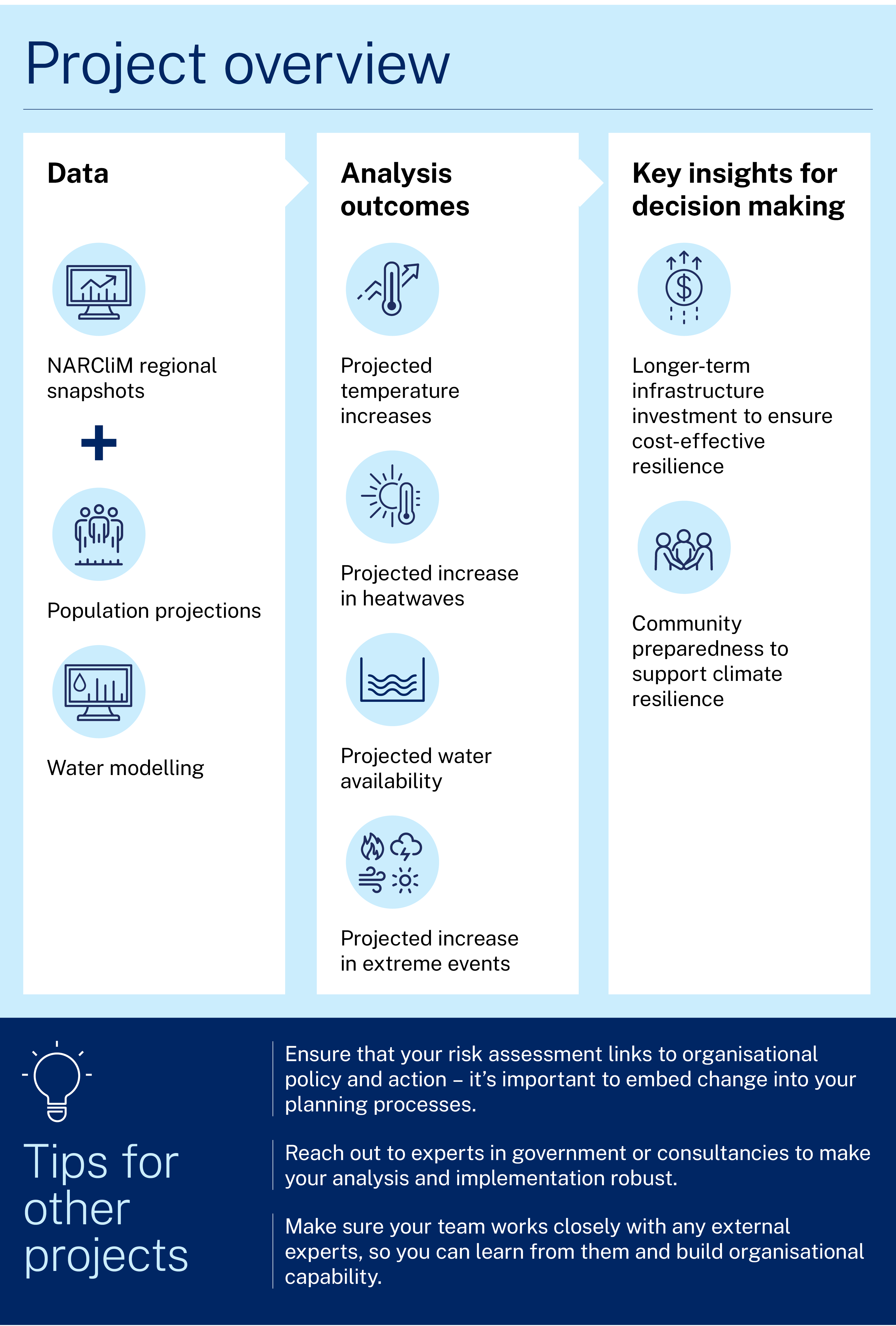
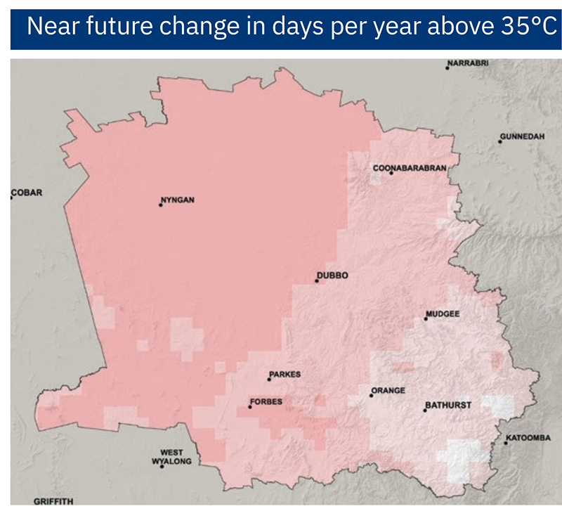
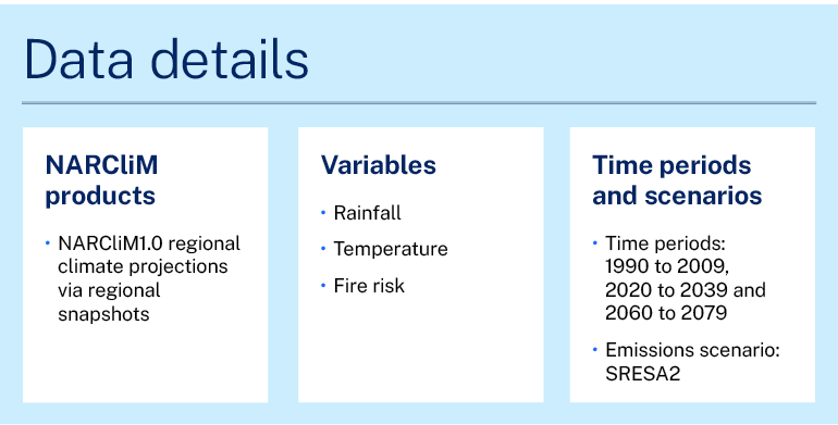
Regional snapshots, built from the first generation of NARCliM data, describe the projected climate changes for the near (2020–39) and far (2060–79) future for each NSW region. The data include changes in temperature, number of hot days and cold nights, rainfall and fire weather.
Orange City Council has recently used the snapshot for their region to develop climate risk plans for their area and community. Lindsay Hall, Sustainability Officer with the council, explains that the work couldn’t have been done without the snapshot information:
The snapshot is the main piece of evidence about why we need a climate risk assessment, and it was central to all our communications with council members and stakeholders. We could have found other data, but this information was localised, so it was easy to see how it was directly relevant to us and our needs.
Project and outcomes
The council drew on the resources of the NSW Department of Planning and Environment to run the climate change risk assessment.
The team began the project with a health check. The Climate Risk Maturity Health Check Tool provides state departments and councils with an assessment and diagnosis of where they are on their climate risk preparedness journey.
Melinda Hillery, Senior Project Officer with the NSW Office of Energy and Climate Change, who assisted on the Orange project, explains that the tool provides a good resource in the risk assessment process. She says, ‘Councils can use it at the beginning of their work on climate change risk to see what’s needed, and can also use it throughout the project to assess progress.'
Taking the results of the health check and the regional snapshot, the team conducted workshops involving all stakeholders and areas of council. Lindsay says:
The assessment process was designed to inform all parts of council’s operations, from infrastructure investment to how we can prepare the community for climate change. This was the first time we had put climate change into our integrated planning and reporting framework.
We looked at what the data mean for us, to set the scene for discussing what we need and why. We used the regional maps to compare Orange with other regions nearby. We also provided current climate information so people had a reference point to understand what the changes meant, such as how many hot days we have now compared with how many hot days we might have in the future.
We explored each hazard and what actions council could take to address the risks.We aimed to integrate adaptations across council areas instead of hazard by hazard, to ensure plans would be efficient and cost‑effective.
Melinda believes that integration is a key area for climate risk assessment. She says:
It’s important to recognise that hazards can interact and compound. When you just look at one risk at a time it can seem ‘not that bad’, but really, we’re looking at a major transition for communities under climate change. That’s why this planning is so crucial.
The final report and recommendations from the risk assessment were presented to the council’s external risk committee and then to the executive leadership team. The recommendation that the report be made part of business-as-usual operations was accepted, and the team will now implement the report, with the support of additional staffing.
Learnings and considerations
Lindsay has a key piece of advice for other councils and organisations looking at climate change risk assessment:
Don’t do it alone. You need an expert - from government or a consultancy - to help work through the process and put all the data into context.
But you also need to make sure you have an internal person working closely with the external expert. This ensures that the consultant understands what the council needs, and also that the internal person gets trained in the process of assessment and linking risk to planning, so they bring that knowledge into council and possibly can run the process in the future.
Lindsay says that the next steps are just as important as the assessment process. He says, ‘With each area and action in the risk assessment, we specified which council document or policy it linked to. This embedding step is very important, to make everything operational.'
Melinda reports that the climate risk assessments template developed as part of the Orange City Council project will be made available as part of the local government toolkit to help other councils.
Case studies

The case study outlines research led by the University of Tasmania with NSW Government agencies assessing air quality improvements in the Port Macquarie public library during smoke from the 2019–2020 fires. It compared central air conditioning with portable HEPA cleaners to evaluate the library’s potential to operate as a community clean‑air shelter.

The Highlands Homegrown Economy project brought together 50 local leaders to map 20 catalytic initiatives and collaboration opportunities. By surfacing hidden projects and strengthening cross-sector trust, the process demonstrated how communities can design regenerative economies that create resilience, jobs, and shared value in a changing climate.
Learn how NARCliM climate projections are being used by various NSW sectors to understand and adapt to climate change.